 FREE SHIPPING ON ORDERS OVER $30
FREE SHIPPING ON ORDERS OVER $30
 Sale!
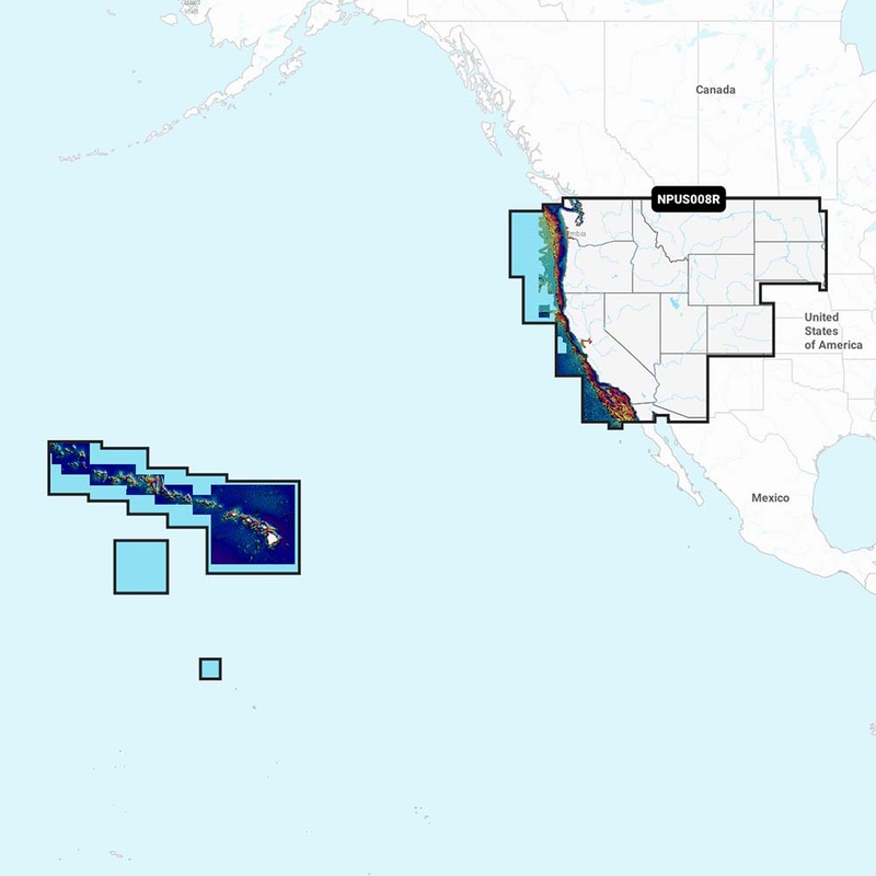
Sale! Navionics Platinum+ charts include all the content of Navionics+ cartography, with integrated offshore and inland mapping, 42,000+ lakes and additional viewing options for relief shading, satellite imagery with SonarChart shading overlay, 3D perspective vi
Navionics Platinum+ charts include all the content of Navionics+ cartography, with integrated offshore and inland mapping, 42,000+ lakes and additional viewing options for relief shading, satellite imagery with SonarChart shading overlay, 3D perspective view, aerial photos, and more.. Features Dock-to-dock Route Guidance- Start your trip with a suggested path; SonarChart Live Mapping Feature- Watch new HD depth maps develop in real-time as your boat moves through the water; Advanced Map Options- Customize your view to focus on the details that matter most; Plotter Sync- Transfer routes and markers, update chart layers, and more-between your compatible chartplotter and the Boating app; Charts & Updates: Nautical Chart- Comprehensive charts are derived from multiple officials, government, and private sources, displayed in a familiar look and feel; SonarChart HD Bathymetry- Innovative 1′ (05 m) bathymetry charts are created by using Navionics proprietary systems that augment existing content with sonar data contributed by the boating community; Community Edits- Get useful local knowledge from edits made by users of the Navionics Boating app on your compatible smart device; Overlays: Relief Shading- Get an easy-to-interpret, clearer view of bottom structure; Satellite Imagery with SonarChart Shading Overlay- Experience an enhanced awareness above and below the waterline; Sonar Imagery- View bottom hardness clearly and in contrasting color; Platinum+ Additional Viewing Options: 3D View- Adjust the perspective of your chart view to highlight key features and enhance awareness; Aerial Photos- Get a better sense of your surroundings; Coverage Areas: Choose from large coverage areas (Large) to more localized chart cuts (Regular); Compatibility: Check the compatibility of Platinum+ content and features with your GPS chartplotter; 1 Subscription is required; 2 Dock-to-dock Route Guidance is for planning purposes only and does not replace safe navigation operations; 3 Subscription not required for SonarChart Live mapping feature on some chartplotter models; requires latest chartplotter firmware release; Specifications Weight: 0.1 lbs; .
Standard Shipping
Cost: $25
Free Shipping
We offer free shipping on orders over $30. Please check the free - shipping eligibility at checkout.
Delivery Time:
It usually takes [3-5] business days for standard shipping. Please note that this is an estimated time frame and may be affected by local holidays, and unforeseen circumstances.

Reviews
There are no reviews yet.